 met with a Hamas delegation")


Professor of Earth and Ocean Sciences at the Canadian University of Victoria, Dr. Edwin Nissen, said that the earthquake that struck Turkey and Syria was one of the largest earthquakes ever recorded on land.
Nissen described the earthquake in Turkey as a “catastrophe”, noting that this type of devastating earthquake usually occurs in oceans rather than on land.
He stressed that the earthquake was not expected despite Turkey’s rich data, some of which date back 1,000 years, and that such a huge earthquake usually only occurs every 100 years.
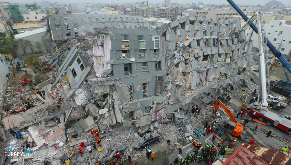
At dawn on February 6, an earthquake of 7.7 degrees struck southern Turkey and northern Syria, followed by another hours later with a magnitude of 7.6 and hundreds of violent aftershocks, which caused great losses in lives and property in both countries.
-Advertisement-
The two earthquakes left destruction in 10 Turkish states: Kahramanmaraş, Gaziantep, Sanliurfa, Diyarbakir, Adana, Adi Yaman, Osmaniye, Hatay, Kilis and Malatya.
In his assessment of the latest quake, Nissen said the first quake, with a magnitude of 7.7, was one of the largest (on land) earthquakes ever recorded.
He added, “It may be among the 5 or 10 largest earthquakes that occur on land, so it caused great damage to the infrastructure and superstructures in the neighboring residential areas.”
He pointed out that after the 1939 earthquake that struck a rift in northern Anatolia and claimed the lives of more than 30,000 people, the 2023 earthquake is the deadliest in Turkey’s history.
The “East Anatolian Fault” or “East Anatolian Fault” is a term that refers to the meeting area between the Arab and African land plate and the Eurasian plate.
Regarding the earthquakes that occurred in the eastern Anatolia rift region in the past, Nissen stated that their magnitude ranged between 6.8 and 7 degrees.
He explained that an earthquake of magnitude 6.8 is 30 times smaller than an earthquake of magnitude 7.8 on the Richter scale, given the energy released.
On the possibility of predicting the recent earthquake, Nissen said that many seismologists did not expect it, although Turkey has rich seismic data dating back 1,000 years, but no one expected the earthquake to occur in this region.
-Advertisement-
He explained that earthquakes with a magnitude of more than 7 in the eastern Anatolian rift may have occurred in the twentieth century and before, but this earthquake was sudden and unexpected.
He noted that the Anatolian plate is under tectonic pressure from the Arab and Eurasian plates, as the Anatolian plate is being pushed towards the west, meaning that everything between the North and East Anatolian faults is being pushed towards the west.
According to Nissen, this movement can cause large earthquakes, such as the last one, every 100 years or less.
Regarding the reasons for the high losses and victims of the earthquake, the Canadian expert referred to the meeting of a number of circumstances that contributed to this, pointing to a widespread saying among seismologists that “it is buildings that kill residents, not earthquakes.”
He explained that “the unqualified buildings, in addition to the earthquake that occurred at night and in the middle of winter, exacerbated the disaster and increased the number of victims.”
He stressed that the buildings in the earthquake area could not have endured these strong tremors, in addition to the long period of shaking, which also increased the extent of the damage.
And he indicated that the strength of the earthquake and the continuation of the tremor for about a minute, according to data issued by the relevant centers, led to the violent shaking of buildings.
He added, “The buildings could withstand the aforementioned tremors if they continued for 10 seconds, but if they continued for a full minute, they collapsed.”
Nessen noted that Turkey is one of the countries with dangerous and active seismic faults and that only a few places in the country are not at risk of large earthquakes.
-Advertisement-
With regard to the movement of the earth in the earthquake zone, Nissen indicated that most of Turkey’s regions are located on the Anatolian plate, which moves westward due to pressure and tectonic movement in the north and south, which caused the recent earthquake.
He added that in the event of a large earthquake, the broken fault line moves a few meters, depending on the size of the earthquake.
Therefore, the recent earthquake caused a fracture along the fault that may be about 300 kilometers long, and the average movement may be about 3 meters, according to Nissen.
He explained that this distance may vary along the fault, and this was confirmed by photographs of the damaged railways and highways.
On Tuesday, the head of the Italian National Institute of Geophysics and Volcanology, Carlo Doglione, said that the Turkey earthquake moved the country (the Anatolian plate) 3 meters to the west, and that it occurred in one of the two seismic fault lines that pass through Turkey.

