 met with a Hamas delegation")


The “Turkish Center for Satellite Communications and Remote Sensing” of the “Istanbul Technical University” monitored via satellite the devastation caused by the earthquake that struck Turkey and Syria.
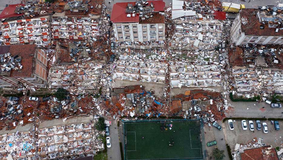
On February 6, the regions of Pazargık and Albistan in the state of Kahramanmaraş, southern Turkey, witnessed two earthquakes, the first with a magnitude of 7.7 and the second of 7.6 degrees, leaving destruction in Marash and the neighboring states, which are Gaziantep, Sanli, Urfa, Diyarbakir, Adana, Adi Yaman, Ottoman, Hatay, Kilis, Malatya and Elazig.
With the occurrence of the two earthquakes and aftershocks that struck northern Syria as well, the ground station in the Turkish center began to monitor the effects of the destruction through the Pleiades (Spot 67) (Worldview3) (GeoEye) satellites.
-Advertisement-
Due to the cloudy weather conditions in the region, the satellites monitored the beginning of the effects of the destruction in the states of Adana and Osmaniye, as well as in the regions of Qarqakhan in Hatay and Turkoglu in Kahramanmaraş and Nordağı, and a reformatory in Gaziantep, and identified the places affected by the earthquake.
By means of satellites, data related to the areas destroyed by the earthquake were recorded, while it was noted that the wreckage and rubble resulting from the disaster closed the main roads in some areas of the Nordağı region.
The satellites also monitored the rescue efforts and the removal of rubble taking place in the affected areas, and the locations of the tents set up by the Turkish Disaster and Emergency Management Agency (AFAD) were identified in different places.
The pictures show that nearly 100 buildings in the Nurdağı district and 150 buildings in the Islahiya district of Gaziantep state were destroyed by the earthquake.
Satellite images clearly showed the destruction in Hatay, where many destroyed buildings, in addition to damaged buildings and closed roads in the Qarqakhan region of the state and the Turkoglu region of Kahramanmaraş.
The center’s deputy director, Nabiye Musa Oglu, said that the project to establish the center began in 1996 and it began operating as an applied research center under the umbrella of Istanbul Technical University in 2000.
She added that the center possesses important capabilities to monitor changes in the geography through the use of satellite images and the processing of relevant data.
And she added, “We provide data from different satellites and process them to contribute to providing the necessary information and data for various studies, especially since remote sensing data is an indispensable resource for information, especially when it comes to large geographical areas.”
-Advertisement-
The Turkish Academy reported that immediately after the two earthquakes occurred in southern Turkey on February 6, the center began monitoring the areas affected by the disaster, despite the cloudy weather conditions there at that time.
She indicated that the center began receiving data and conducting studies to identify damaged and intact buildings using various image processing techniques and artificial intelligence techniques.
And she added, “There are many damaged buildings. We see that the destruction is relatively less in Adana, while we can clearly identify through the pictures the damaged and intact buildings.”
She revealed that the Center for Satellite Communications and Remote Sensing constantly shares the images, data and information it obtains with research and related institutions.

